Showing posts with label wreck. Show all posts

2022-03-20

Third Shipwreck Today, This One Has Treasure! March 20, 2022, UFO Sighting News.


Below you see lots of boxes holding treasure. The weight of the treasure makes the boxes stay in the same place they were when the ship sunk. 


Date of discovery: March 20, 2022
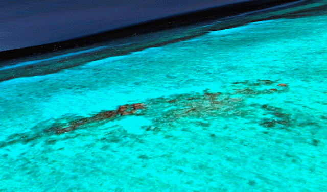
Location of discovery: Uluma Reef, 
Milne Bay, Papua New Guinea 
Google Coordinates:  11° 6'23.30"S 150°57'47.66"E 

I was going over Google Earth Map and had a bit of bad luck today. Found a third sunken ship. This one was laden with treasure. The wooden hull of the craft is mostly gone, but its boxes of metallic objects, coins, swords, cannons and more are strewn about. I also see an area where there are about 8-10 wooden boxes with treasure in them. By now the wood is mostly gone, but the treasure is visible when I use a special focus on my photo program. It really pops out. There is something there, maybe millions worth of gold and silver, just waiting for someone to go get it. 

This might not look like a shipwreck to many people, but as you know...I have an eye for it. It takes years of practice before it's easy to do. 


There is also a legend of a Japanese transport (plane or ship is unknown) in WWII that left Papua New Guinea with 375 million US in gold bars, heading to Japan with boxes of gold bricks. I wonder, if this is that aircraft? Aircraft metal would deteriorate faster since is thin aluminum and corrodes more easily. The thickness of the craft does seem similar to what we see here. Also would explain the debris field around it. 

Scott C. Waring - Taiwan 

I believe it's the metallic luminosity of gold that causes the photo to adjust this was below. The boxes are gone, but the gold bars mostly remain, some is strewn about. 


Ancient Shipwreck Off Island Of Sabara, Google Earth Map, March 20, 2022, UFO Sighting News.


Date of discovery: March 20, 2022
Location of discovery: Island of Sabara, Netherlands
Google coordinates:  11° 6'14.40"S 153° 4'52.84"E

I was searching on Google Earth map when I found an old ship wreck of the edge of Sabara Island. Google ruler measures the ship to be 40 meters long and 7.5 meters wide. I can clearly see a tall mast at its back quarter area. The hull of the ship is dark in the depth of the ocean, and its difficult to decide if its metal or wooden. This doesn't resemble any fishing vessel I have ever seen. I think for this wreck to go overlooked for so long, it must be a few hundred years old. I thought this one is undocumented and may be of archeological value to a museum who wishes to explore and recover any museum worthy material it may have. I believe it to be an undocumented ship wreck. I could find nothing of it when doing a Google search.
Scott C. Waring - Taiwan